Join World's Fastest Growing B2B Network
Join World's Fastest Growing B2B Network


| Quantity | 0 - 1 | 5 - 20 |
| Price | 2500 | 2000 |
| MOQ | 1 set |
| Port | Shenzhen |
| Packaging | Aluminum case with carton outside |
| Lead Time | 3-5 working days |
| Color | Black | Maximum prospecting depth | 200m |
| Layer division | 10-100 |
Free upgrading at the original price after purchasing within six months
ADMT series products use the earth's natural electromagnetic field as the working field source to study the electrical structure inside the earth. According to the principle that electromagnetic waves of different frequencies have different skin depths in the conductive medium, the earth's electromagnetic response sequence from high frequency to low frequency is measured on the surface of the earth. , to study the difference in electrical changes of underground geological bodies at different depths, and to determine the occurrence state of underground geological bodies
Since the development of the short-wire D75 electrical method in 1973, we have been working hard. This high-density MT geophysical probe uses 16-channel simultaneous input measurement to obtain a stable field source, solves the problem of natural electric field changes at any time, and solves repeated measurement data. The shortcomings of different profiles, combined with light and efficient, precise and intelligent and advanced Internet of Things technology, are well received by new and old users.
Applications:
Engineering Investigation: Underground cavity, coal mine goaf, dyke piping leak detection, engineering geophysical prospecting, etc.
Mineral Exploration: Exploration for metallic and non-metallic minerals, geothermal hot springs, etc.
Water Source Survey: Exploration for groundwater resources, geological structure stratification, etc
Environmental Census: Environmental protection surveys, leak detection of waste landfills, geological disaster surveys, etc
Advantages:
High precision and strong anti-interference: The core module of the instrument adopts an integrated package, with high precision and greatly enhanced anti-interference.
Equipped with a high-performance processor to run a variety of algorithms, the output is stable and accurate, ensuring the accuracy of the instrument in various environments.
Automatic drawing: After the measurement is completed, a 2D, 3D color map and a variety of curve graphs will be generated.
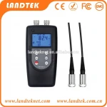
Simple operation with 10.1-inch touch screen.
Learn to operate in 5 minutes.
Depth adjustable, intelligent and flexible: Each product has a variety of adjustable depths, the number of channels can be set.
The two measurement modes of MN and TT can be switched, which is very intelligent and flexible.
Multi-screen data sharing: Mobile phone, instrument, computer, remote terminal data sharing, only need to log in with the same account.
And support data sharing between multiple accounts.
Free upgrade, value-added purchase: The instrument includes a full set of APP software to support online free upgrades.
And since the purchase of 6 months to maintain the value of other products.
Lifetime technical support: Data processing and analysis, instrument maintenance online technical guidance and other services are all supported for life.
Patented product: Obtained multiple invention patents (Patent No.: ZL201310205318.9, ZL201110454869.X, ZL201320054153.5, ZL201320303919.9)
Guilin National High-Tech University Scientific Park, No. 108, Qilidian Road, Qixing District
One moment please
 Member's Area
 Messages
  Need Help