Join World's Fastest Growing B2B Network
Join World's Fastest Growing B2B Network


| Place of Origin | Hunan, China | Brand Name | PQWT |
| Model Number | PQWT-M100 | How to draw profile map and curve graph | Automatically draw curve graph and profile map in instrument |
| Patents | 7 technology and appearance design patents | Instrument language | Support English, French, Chinese and Arabic |
| Certificates | ISO2008:9001, SGS and BV certified | Gold Supplier/Assessed Supplier | Yes |
| storage capacity | can store 999 measuring lines data and 999points data each line | OEM | available |
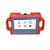
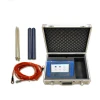
| Product Name | PQWT-M100 underground water detector manufacturer | Measuring Depth | 100m underground water detector manufacturer |
| Power Supply | DC12V 4000mAh Built-in Battery |
For more information&best price, contact whatsapp/wechat 008618817121525
Why Choose us
PQWT-M100 geophysical prospecting mapping with one button underground water finder utilize the natural electric field as working electromagnetic field source, based on the resistivity differences of underground rock , ore or groundwater, measure natural electric field on the ground of N different frequencies electric field component. According to their different variation to study the abnormal changes which is caused by different geological bodies ,to solve the geological problems of a kind of electrical prospecting method.
PQWT-M100 natural electric field a key to mapping geophysical prospecting underground water detector is our latest research and development of products, using a number of patented technologies. The instrument weight is very light to carry easily , the measuring line need only 10 meters, one person will be able to complete the operation, saving manpower, full touch screen, simple operation, external high-capacity memory card, with the function of real-time mapping with only one button, finding high resistance (fault zone), low resistance (such as water, mining census) through real-time mapping directly display geological abnormal on the measuring site. After data collection by the unique built-in computing functions, the instrument can automatically draw curve graph and profile map with only one button, according to the profile map, you can clearly understand the geological structure and quickly determine the location of ore body (seam), hollow (cave), water (aquifer) etc.
100M SGS and BV certified automatic mapping underground water detector manufacturer


100M SGS and BV certified automatic mapping underground water detector


100M SGS and BV certified automatic mapping underground water detector


Is it difficult to operate and make the graph?
The instrument is easy to operate, you can find the share how-to video on Youtube
(URL: https://www.youtube.com/watch?v=YPxKh3UIV3c) , and we will send you the detailed operation manual via email. If you have some basis of computer operating, generally it only need 2hour to manage it.

100M SGS and BV certified automatic mapping underground water detector manufacturer

150M SGS and BV certified automatic mapping underground water detector manufacturer

Room 301, Building A16, Jiahai Industrial Park, No. 1318 Zhongqing Road, Kaifu District
One moment please
 Member's Area
 Messages
  Need Help